In the Primo search box, type map and another broad keyword(s).
Example: I need a map of Pennsylvania mining sites to include in my history paper.
1) Search map and any additional keyword(s), such as: Pennsylvania mining map
2) Tweak Your Result on the right side: Under Resource Type, select Map (or "Show More" if you don't see it to expand the category). Most maps will be online resources.

3) I got 28 results, including this historic Anthracite Coal Fields of Pennsylvania.

If you do not get many results, try a broader keyword or remove any extra limiters (i.e. publication date, limit to Kemp Library, etc.).
Tip: If you want print maps, you can limit to Kemp Library. However, this may yield too few results.
If you get stuck, ask a librarian for help (see Stuck? page).
Start with broad keywords when searching Primo.
If you want print maps, books, or atlases at the library, then click on Kemp Library limiter in the Tweak Your Results column. Note: You may not yield many results since we have more online map resources than in print.
If you use too many limits in the Tweak Your Results column, you may not get many results. Try a broader keywords or remove any extra limiters (i.e. publication date, limit to Kemp Library, etc.).

Besides Kemp Library's Primo catalog, the USGS website, and the US Census Bureau, you can find more historic maps here:
To search for maps: Type in a location and map (i.e. Monroe County Pennsylvania Map). On the results page, try limiting on the left side in either the subject box (Monroe County (Pa)--Maps) or the location box (Pennsylvania).

The Sanborn Map Company, the best known of the US fire-insurance map producers, has made maps since 1867. The fire insurance maps produced by Sanborn show building footprints, building material, height or number of stories, building use, lot lines, road widths and water facilities. The maps also show street names and property boundaries of the time. This collection of maps is historically significant as it is sometimes the best detailed map of a town or city dating from the mid 1800s.


Searches across 17 Library of Congress digital collections, including railroad maps, civil war maps, general maps, panoramic maps, and Sanborn maps.

U.S. Geological Survey (USGS) publishes topographic maps -- maps that show an area’s physical and cultural features at a particular time. Through the years, maps of specific areas have been updated. Learn more about the USGS Historical Topographic Map Collection.
3 Ways to Find USGS Topographic Maps:
1) TopoView: Search for USGS topographic maps
2) The National Map Download Client:
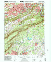
3) Visit Us! Kemp Library has a USGS topographic maps collection for Pennsylvania (7.5 minute series quadrangle, 1:24,000 scale). Come to the Circulation Desk and ask for help from a librarian.
A tutorial by USGS scientist and topoView developer Chris Garrity demonstrating how to use topoView version 2.1. TopoView let's you access and download maps free of charge from the USGS's Historical Topographic Map Collection, published between 1884 and 2006.
Select a location and then choose a map type (i.e. administrative, physiography, transportation, etc.). Download a PDF or JPG. Available maps may vary by country.
CIA Maps >> Selected Afghanistan.

Published by the CIA, The World Factbook provides information on the history, people, government, economy, energy, geography, communications, transportation, military, and transnational issues for 267 world entities. Our Reference tab includes: maps of the major world regions, as well as Flags of the World, a Physical Map of the World, a Political Map of the World, a World Oceans map, and a Standard Time Zones of the World map.
The World Factbook >> Selected Afghanistan

Geography Reference Maps include a variety of map types that show the boundaries and names of geographic areas for which the Census Bureau tabulates statistical data. In some cases, the name is only in the form of a geographic code, such as a census block number. Some types of reference maps include geographic features and their identifiers that are coincident with the boundary. Examples are roads and water features. Reference maps can include additional features such as railroads to aid users in orienting themselves to the area depicted on the map.

Search for aerial photographs:
Example: Search for East Stroudsburg. Select an era (time period) next to the search box. Then click on a red dot. View information and preview the photo on left side. Choose a resolution you want to download.


Don't struggle...Ask a Librarian!
If you can't find the map you need, contact the library.